Traffic & Parking
scroll to: getting there / parking / road closures & traffic management
GETTING THERE
Omaha is situated on its own peninsula on the north eastern coast of the Auckland region. Although it is physically connected to nearby Tawharanui Regional Park, all vehicular access is via the Broadlands Road causeway from Matakana / Point Wells.
It's important to be aware that the causeway is part of the half marathon course so if you are arriving later in the day, you can expect to see many runners on the causeway shoulder. Please observe the speed restrictions and give the athletes plenty of room.
Arriving on the Omaha side of the causeway, you may encounter traffic management controls and a "stop-go" operation approaching the main roundabout at the junction of Broadlands Road and Omaha Drive. Those heading for the golf course will turn left here whilst competitors and those heading for the shops continue straight ahead. Please be patient and obey the signals from the traffic controllers as there may be some small delays from time-to-time at this point.
Tip: If you are unfamiliar with the venue, set your GPS to...
223 Mangatawhiri Road, Omaha, Auckland
... which takes you right to the entrance of the reserve.
Note: You may be turned around prior to this point if the event venue parking is full.
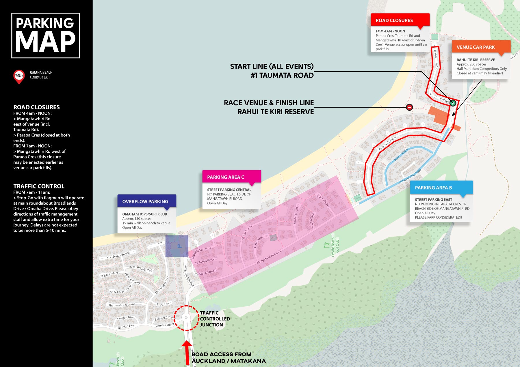
Parking Map
Premium event parking is at the event venue where approx 200-250 spaces are available on the reserve and within a paved parking area opposite. These spaces are reserved for those in the half marathon and are usually filled well before 7am. In the unlikely instance that they are not, access will close at 7am sharp anyway to allow the events to begin.
Once the venue car park has been closed, vehicles travelling down Mangatawhiri Road will be turned around at the southern end of Tohora Cres. You'll find lots of street parking on Tohora or right along Mangatawhiri Road. Past experience has suggests that the furthest event parking will extend is about 1km (15 minutes easy walk) from the finish line.
Please remember to park considerately. DO NOT park across driveways, on grass medians or on private property. Auckland Council parking wardens are almost always present at our events.
ROAD CLOSURES
& TRAFFIC MANAGEMENT
It is imperative for the safe operation of the event that certain roads are closed to traffic at specified times on race day. The map below lists the road closures and other traffic management measurements that will be in place on race day so you know what to expect, when to expect it and for how long.
Info for Residents
Traffic restrictions are imposed for the minimum time possible to create as little delay and inconvenience as we can to local residents. Unless it would be unsafe to do so, residents will be permitted access to and from the homes during the event. Please be respectful of the entrants and aware that they are permitted to be on the road at this time. Please drive at no more than walking pace whilst operating a vehicle within the closure area. Keep a close lookout for pedestrians who may approach faster than you expect or from unexpected directions.
The event organisers wish to place on record their sincere thanks to Auckland Council, Auckland Transport and local residents for their assistance in the safe operation of this fun community focussed, fitness event.
Road Closure & Traffic Management Map